Highlight Keine Abbildung Keine Abbildung Los 829 WEST INDIES -- "OCCIDENTALIS AMERICAE PARTIS, vel, earum Regionum quas Christophorus Columbus primu 829WEST INDIES -- "OCCIDENTALIS AMERICAE PARTIS, vel, earum Regionum quas Christophorus Columbus primu Burgersdijk & Niermans WEST INDIES -- "OCCIDENTALIS AMERICAE PARTIS, vel, earum Regionum quas Christophorus Columbus primu[m] detexit (…)". (Frankfurt a/M.), Th. de Bry,... Auf die Merkliste Live
Keine Abbildung Keine Abbildung Los 1140 Opticaprent 1140Opticaprent Veilinghuis Timothy Antieke handgekleurde opticaprent "la naissance". - Antique hand colored opticaprent “la naissance” Auf die Merkliste Live
Mindestpreis nicht eingehalten Keine Abbildung Keine Abbildung Keine Abbildung Los 171 Lucia Riccelli und Giada Iafisco: for ever me #3 171Lucia Riccelli und Giada Iafisco: for ever me #3 Auktionshaus im Kinsky ,: Lucia Riccelli und Giada Iafiscofor ever me #32022Öl auf Druck auf Alu-Dibond-Platte; gerahmt47,5 x 47,5 cm (Rahmen-Ausschn.)Monogrammiert rech... Auf die Merkliste Timed
Mindestpreis nicht eingehalten Keine Abbildung Keine Abbildung Keine Abbildung Keine Abbildung Los 2 PICCOLOMINI, ALESSANDRO. 1508-1579. La sfera del Mono / Le stelle fisse. Venice: Nicolo Bevilacq... 2PICCOLOMINI, ALESSANDRO. 1508-1579. La sfera del Mono / Le stelle fisse. Venice: Nicolo Bevilacq... Bonhams PICCOLOMINI, ALESSANDRO. 1508-1579. La sfera del Mono / Le stelle fisse. Venice: Nicolo Bevilacqua, 1561. 2 parts in 1 volume. 4to (195 x 145 mm)... Auf die Merkliste Timed
Mindestpreis nicht eingehalten Keine Abbildung Keine Abbildung Keine Abbildung Keine Abbildung Keine Abbildung Los 54 JEFFERYS WEST INDIES, COMPLETE. JEFFERYS, THOMAS. The West-India Atlas: or, A Compendious Descri... 54JEFFERYS WEST INDIES, COMPLETE. JEFFERYS, THOMAS. The West-India Atlas: or, A Compendious Descri... Bonhams JEFFERYS WEST INDIES, COMPLETE. JEFFERYS, THOMAS. The West-India Atlas: or, A Compendious Description of the West-Indies. London: Robert Sayer and... Auf die Merkliste Timed
Mindestpreis nicht eingehalten Keine Abbildung Keine Abbildung Keine Abbildung Keine Abbildung Keine Abbildung Keine Abbildung Keine Abbildung Keine Abbildung Los 55 LARGE FINE COPY IN ORIGINAL BOARDS. LA PEROUSE, JEAN FRANCOIS GALAUP DE. 1741-1788. Voyage de La... 55LARGE FINE COPY IN ORIGINAL BOARDS. LA PEROUSE, JEAN FRANCOIS GALAUP DE. 1741-1788. Voyage de La... Bonhams LARGE FINE COPY IN ORIGINAL BOARDS. LA PEROUSE, JEAN FRANCOIS GALAUP DE. 1741-1788. Voyage de La Perouse autour du monde.... Paris: L'Imprimerie d... Auf die Merkliste Timed
Mindestpreis nicht eingehalten Keine Abbildung Keine Abbildung Keine Abbildung Los 60 SALT'S VOYAGE TO ABYSSINIA. SALT, HENRY. 1780-1827. A Voyage to Abyssinia, and Travels into the ... 60SALT'S VOYAGE TO ABYSSINIA. SALT, HENRY. 1780-1827. A Voyage to Abyssinia, and Travels into the ... Bonhams SALT'S VOYAGE TO ABYSSINIA. SALT, HENRY. 1780-1827. A Voyage to Abyssinia, and Travels into the Interior of That Country, Executed Under the Order... Auf die Merkliste Timed
Mindestpreis nicht eingehalten Keine Abbildung Keine Abbildung Keine Abbildung Keine Abbildung Keine Abbildung Los 66 FINE COPY OF CRAWFURD'S EMBASSY TO CHINA. CRAWFURD, JOHN. 1783-1868. Journal of an Embassy from ... 66FINE COPY OF CRAWFURD'S EMBASSY TO CHINA. CRAWFURD, JOHN. 1783-1868. Journal of an Embassy from ... Bonhams FINE COPY OF CRAWFURD'S EMBASSY TO CHINA. CRAWFURD, JOHN. 1783-1868. Journal of an Embassy from the Govenor-General of India to the Courts of Siam... Auf die Merkliste Timed
Mindestpreis nicht eingehalten Keine Abbildung Keine Abbildung Keine Abbildung Los 69 'APPARENTLY ONLY A FEW COPIES WERE ISSUED COLORED.' ALLEN, WILLIAM. 1793-1864. Picturesque Views... 69'APPARENTLY ONLY A FEW COPIES WERE ISSUED COLORED.' ALLEN, WILLIAM. 1793-1864. Picturesque Views... Bonhams 'APPARENTLY ONLY A FEW COPIES WERE ISSUED COLORED.' ALLEN, WILLIAM. 1793-1864. Picturesque Views on the River Niger, Sketched During Lander's Last... Auf die Merkliste Timed
Keine Abbildung Keine Abbildung Los 30 CHRISTOPH LUDWIG AGRICOLA (GERMAN 1665 - 1719), AN EXOTIC BIRD ON A BRANCH 30CHRISTOPH LUDWIG AGRICOLA (GERMAN 1665 - 1719), AN EXOTIC BIRD ON A BRANCH Dreweatts 1759 CHRISTOPH LUDWIG AGRICOLA (GERMAN 1665 - 1719) AN EXOTIC BIRD ON A BRANCH Bodycolour 27 x 20cm (10½ x 7¾ in.) Provenance: ... Auf die Merkliste Live
Keine Abbildung Keine Abbildung Los 209 Y A SHELL ENCRUSTED MIRROR, LATE 20TH CENTURY 209Y A SHELL ENCRUSTED MIRROR, LATE 20TH CENTURY Dreweatts 1759 Y A SHELL ENCRUSTED MIRROR LATE 20TH CENTURY 96cm high, 60cm wide Condition Report: Overall condition reflects this... Auf die Merkliste Live
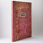
Keine Abbildung Keine Abbildung Keine Abbildung Los 210 Charles I (King of England) Basilika [graece]. The Workes of King Charles the Martyr, by James Fl... 210Charles I (King of England) Basilika [graece]. The Workes of King Charles the Martyr, by James Fl... Forum Auctions Charles I (King of England) Basilika [graece]. The Workes of King Charles the Martyr, 2 vol. in 1, engraved frontispiece, additional engraved titl... Auf die Merkliste Live
Keine Abbildung Los 207 Bacon (Sir Francis) and Francis Godwin. The History of the Reigns of Henry the Seventh, Henry the... 207Bacon (Sir Francis) and Francis Godwin. The History of the Reigns of Henry the Seventh, Henry the... Forum Auctions Bacon (Sir Francis) and Francis Godwin. The History of the Reigns of Henry the Seventh, Henry the Eighth, Edward the Sixth, and Queen Mary, first ... Auf die Merkliste Live
Keine Abbildung Los 165 Kent, Ulcombe, near Maidstone.- A Map of the Hopper Farm In the Parishes of Ulcomb & Boughton, Be... 165Kent, Ulcombe, near Maidstone.- A Map of the Hopper Farm In the Parishes of Ulcomb & Boughton, Be... Forum Auctions Kent, Ulcombe, near Maidstone.- A Map of the Hopper Farm In the Parishes of Ulcomb & Boughton, Belonging to Mr. Stephn. Hadfield, Gent., pen and i... Auf die Merkliste Live
Keine Abbildung Los 208 Weever (John) Ancient Funerall Monuments within the United Monarchie of Great Britaine, Ireland, ... 208Weever (John) Ancient Funerall Monuments within the United Monarchie of Great Britaine, Ireland, ... Forum Auctions Weever (John) Ancient Funerall Monuments within the United Monarchie of Great Britaine, Ireland, and the Islands adjacent, first edition, engraved... Auf die Merkliste Live
Keine Abbildung Los 224 Trade card.- Map & print dealer.- Lockley (David) After. The following particulars made & sold ve... 224Trade card.- Map & print dealer.- Lockley (David) After. The following particulars made & sold ve... Forum Auctions Trade card.- Map & print dealer.- Lockley (David) After. The following particulars made & sold very cheap by Robert Hulton at ye corners of Pallm... Auf die Merkliste Live
Keine Abbildung Los 287 Kent.- Lambarde (William) A Perambulation of Kent, first edition, for Ralphe Newberie, 1576. 287Kent.- Lambarde (William) A Perambulation of Kent, first edition, for Ralphe Newberie, 1576. Forum Auctions Kent.- Lambarde (William) A Perambulation of Kent, first edition, title within wide woodcut border, woodcut initials, lacking map, H1-H4 and 2Y3-2... Auf die Merkliste Live
Keine Abbildung Los 163 South Sea Bubble.- Williams (Thomas, London merchant) Letter signed to Niccolo Caragiani, a busin... 163South Sea Bubble.- Williams (Thomas, London merchant) Letter signed to Niccolo Caragiani, a busin... Forum Auctions South Sea Bubble.- Williams (Thomas, London merchant) Letter signed to Niccolo Caragiani, a business associate in Venice, 1p. in Italian, with add... Auf die Merkliste Live
Keine Abbildung Los 297 India.- Bengal.- East India Company (The) Commission received by Edward Hindley at Fort William, ... 297India.- Bengal.- East India Company (The) Commission received by Edward Hindley at Fort William, ... Forum Auctions India.- Bengal.- East India Company (The) Commission received by Edward Hindley at Fort William, Bengal, printed document with manuscript insertio... Auf die Merkliste Live
Keine Abbildung Los 153 Kent, Bonnington.- Charter of John Taillor of Castle Donington confirms to John Bonyngton armiger... 153Kent, Bonnington.- Charter of John Taillor of Castle Donington confirms to John Bonyngton armiger... Forum Auctions Kent, Bonnington.- Charter of John Taillor of Castle Donington [?Leicesterhire or Berkshire] confirms to John Bonyngton armiger and Nicholas from ... Auf die Merkliste Live
Keine Abbildung Los 198 Kent, Cranbrook.- Maps and documents relating to the Angley Park Estate, Cranbrook, including 9 (... 198Kent, Cranbrook.- Maps and documents relating to the Angley Park Estate, Cranbrook, including 9 (... Forum Auctions Kent, Cranbrook.- Maps and documents relating to the Angley Park Estate, Cranbrook, including 9 (8 pen and ink and one pencil) estate maps, large ... Auf die Merkliste Live
Keine Abbildung Los 0 ETRUSCA AUCTIONS - 4th April Sale 0ETRUSCA AUCTIONS - 4th April Sale Etrusca Auctions Ltd ETRUSCA AUCTIONS - 4th April Sale Auf die Merkliste Live
Keine Abbildung Keine Abbildung Keine Abbildung Keine Abbildung Keine Abbildung Keine Abbildung Keine Abbildung Los 114 Oliver Gal (American, 20th C.) Set of 2 Baseball Posters on Paper 114Oliver Gal (American, 20th C.) Set of 2 Baseball Posters on Paper Lion and Unicorn Pair of framed blueprint style reproductions of the original patent designs for a baseball by John E. Maynard and William T. Brown. These visually... Auf die Merkliste Live
Keine Abbildung Los 690 Homann Heirs (fl. 1730- 1848), after, print Twin Hemisphere World Astrological Map. Framed behind 690Homann Heirs (fl. 1730- 1848), after, print Twin Hemisphere World Astrological Map. Framed behind Potteries Auctions Homann Heirs (fl. 1730- 1848), after, print Twin Hemisphere World Astrological Map. Framed behind glass. Size incl. frame, Height: 90cm Width: 100... Auf die Merkliste Live
Keine Abbildung Keine Abbildung Keine Abbildung Los 72 A fine late-18th-century pocket globe, based on one by Herman Moll C. 1775 72A fine late-18th-century pocket globe, based on one by Herman Moll C. 1775 Doyle New York [POCKET GLOBE][ANONYMOUS, after HERMAN MOLL]. A Correct Globe with the new Discoveries. [London: circa 1775]. A 2 3/4 inch pocket globe, with 12 h... Auf die Merkliste Live
Keine Abbildung Los 61 A German map published during the American Revolution 61A German map published during the American Revolution Doyle New York [MAP-NORTH AMERICA]LOTTER, MATTHEW ALBERT. A Map of the Provinces of New-York and New-Jersey, with a part of Pennsylvania and the Province of Queb... Auf die Merkliste Live
Keine Abbildung Keine Abbildung Keine Abbildung Keine Abbildung Los 60 A fine example of a mid-nineteenth-century French school atlas 60A fine example of a mid-nineteenth-century French school atlas Doyle New York [MAPS - ATLAS]DUFOUR, H. Atlas Universel Physique, Historique et Politique de Géographie Ancienne et Moderne. Paris: Armand le Chevlier, 1861. Con... Auf die Merkliste Live
Keine Abbildung Los 64 John Speed's carte à figures of Scotland, with portraits of King James I and his family 64John Speed's carte à figures of Scotland, with portraits of King James I and his family Doyle New York [MAP - SCOTLAND]SPEED, JOHN. The Kingdome of Scotland. London: John Sudbury & George Humble, 1610 [but 1611 or later]. First edition. Engraved map... Auf die Merkliste Live
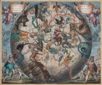
Keine Abbildung Keine Abbildung Keine Abbildung Keine Abbildung Los 59 A finely colored map of the southern stars from Cellarius' celebrated celestial atlas 59A finely colored map of the southern stars from Cellarius' celebrated celestial atlas Doyle New York [MAP - CELESTIAL]CELLARIUS, ANDREAS. Haemisphaerium Stellatum Australe Aequali Sphaerarum Proportione. [Amsterdam: G. Valk & P. Schenk, 1708.] Eng... Auf die Merkliste Live
Keine Abbildung Los 63 A rare and early broadside map of the Battle of Bunker Hill 63A rare and early broadside map of the Battle of Bunker Hill Doyle New York [MAP - REVOLUTIONARY WAR] SAYER, ROBERT; and JOHN BENNETT. A Plan of the Battle of Bunkers Hill fought on the 17th of June 1775, by an Officer on ... Auf die Merkliste Live
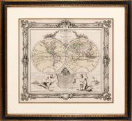
Keine Abbildung Los 58 An unusual French double-hemisphere world map 58An unusual French double-hemisphere world map Doyle New York [MAP - WORLD]BRION DE LA TOUR. Mappe-monde dressée pour l'étude de la géographie rélativement aux auteurs les plus modernes... Paris: Desnos, 1765... Auf die Merkliste Live
Keine Abbildung Los 328 A fine Judicial appointment for a Nebraska judge, signed by Lincoln and Seward 328A fine Judicial appointment for a Nebraska judge, signed by Lincoln and Seward Doyle New York LINCOLN, ABRAHAMJudicial appointment signed. Washington: 2 June 1863. Partially printed document on vellum accomplished in manuscript and signed i... Auf die Merkliste Live
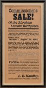
Keine Abbildung Keine Abbildung Los 27 Rare broadside advertising the sale of Abraham Lincoln's birthplace in Kentucky 27Rare broadside advertising the sale of Abraham Lincoln's birthplace in Kentucky Doyle New York [LINCOLN, ABRAHAM]Commissione's Sale! Of the Abraham Lincoln Birthplace. Vicinity of The Lincoln Spring Farm, LaRue County, Kentucky: 28 August 19... Auf die Merkliste Live
Keine Abbildung Keine Abbildung Keine Abbildung Los 71 Cary's up-to-date 3-inch pocket globe, showing the tracks of Captain Cook's voyages 1791 71Cary's up-to-date 3-inch pocket globe, showing the tracks of Captain Cook's voyages 1791 Doyle New York [POCKET GLOBE]CARY, JOHN and WILLIAM. Cary’s Pocket Globe; agreeable to the latest discoveries. London: J. and W. Cary, 1791. A 3-inch Terrestrial... Auf die Merkliste Live
Keine Abbildung Keine Abbildung Keine Abbildung Los 73 Mogg's paper globe, an early 19th-century toy for teaching children geography and astronomy London: 73Mogg's paper globe, an early 19th-century toy for teaching children geography and astronomy London: Doyle New York [GLOBE - EDUCATIONAL TOY]MOGG, EDWARD. Mogg's Dissected Globe. London: Edward Mogg, March 1st, 1812. Twelve pieces of printed and hand-colored car... Auf die Merkliste Live
Keine Abbildung Los 62 Separately published broadside map of the 1776 Seige of Charleston during the Revolutionary War 62Separately published broadside map of the 1776 Seige of Charleston during the Revolutionary War Doyle New York [MAP - REVOLUTIONARY WAR] SAYER, ROBERT; and JOHN BENNETT. A Plan of the Attack on Fort Sullivan, the key of Charlestown, in South Carolina, on th... Auf die Merkliste Live
Keine Abbildung Keine Abbildung Keine Abbildung Keine Abbildung Los 70 A rare 3 1/2 inch pocket globe by Smith 70A rare 3 1/2 inch pocket globe by Smith Doyle New York [POCKET GLOBE]SMITH, J[OHN] and C[HARLES]. A New Terrestrial Globe; from the best authorities. London: by J. Smith and sold by C. Smith, 172 Stran... Auf die Merkliste Live
Keine Abbildung Keine Abbildung Keine Abbildung Keine Abbildung Keine Abbildung Los 118 The Treaty of Versailles that ended World War I 118The Treaty of Versailles that ended World War I Doyle New York [WORLD WAR I]Traite de Paix / Treaty of Peace between the Allied and Associated Powers and Germany and Protocol Signed at Versailles, June 28, 191... Auf die Merkliste Live
Keine Abbildung Keine Abbildung Keine Abbildung Keine Abbildung Keine Abbildung Keine Abbildung Keine Abbildung Keine Abbildung Keine Abbildung Los 35 Accords-Puncte von 1715 Strahlsund Stralsund mit Karte Strahlsundt investi Pierre Husson 35Accords-Puncte von 1715 Strahlsund Stralsund mit Karte Strahlsundt investi Pierre Husson Auktionshaus Bad Homburg Accords-Puncte, Welche am 23. Dec. 1715. Zwischen denen Hohen-Nordischen Alliirten Und der Cron-Schweden, Wegen Ubergabe Der Stadt Strahlsund, Ges... Auf die Merkliste Live
Keine Abbildung Keine Abbildung Keine Abbildung Los 36 Antique Nautical Map of the Gulf of Mexico and Florida 36Antique Nautical Map of the Gulf of Mexico and Florida Lion and Unicorn Antique 1777 nautical map depicting the Gulf of Mexico and the Florida coastline, a remarkable historical artifact from the late 18th century. Thi... Auf die Merkliste Live
Keine Abbildung Los 1199 Topographic map of Hattem 1199Topographic map of Hattem Derksen Veilingbedrijf Topographic map of Hattem, external dimensions are 32x40 cm Auf die Merkliste Live
Keine Abbildung Los 1223 Jan van der Meer 1223Jan van der Meer Derksen Veilingbedrijf Jan van der Meer (1942-2024) Ship on the high seas during a storm, panel dated 1994, 29x40 cm Auf die Merkliste Live
Keine Abbildung Keine Abbildung Keine Abbildung Los 4198 Brass Dip Cicle 4198Brass Dip Cicle Derksen Veilingbedrijf Brass Dip Cicle, marked L. Casella maker to the Admiralty & Ordnance London No 54, in walnut case, 13.5 cm high, 17.5x14 cm Auf die Merkliste Live
Keine Abbildung Los 1198 Topographic map of Doesburg 1198Topographic map of Doesburg Derksen Veilingbedrijf Topographic map of Doesburg, external dimensions are 38x41 cm Auf die Merkliste Live
Keine Abbildung Los 1173 Topographic map of Peru 1173Topographic map of Peru Derksen Veilingbedrijf Topographic map of Peru, ca. 1700, external dimensions are 57x67 cm Auf die Merkliste Live
Keine Abbildung Los 1197 Topographic map of Doesborgh 1197Topographic map of Doesborgh Derksen Veilingbedrijf Topographic map of Doesborgh, external dimensions are 42x37 cm Auf die Merkliste Live
Keine Abbildung Los 2109 Lot various items 2109Lot various items Derksen Veilingbedrijf Box with various earthenware based on antique examples and 3 wall decorations including topographic maps, Graveland and Department of Den Oude IJs... Auf die Merkliste Live
Keine Abbildung Los 1252 Jan van der Meer 1252Jan van der Meer Derksen Veilingbedrijf Jan van der Meer (1942-2024) Cityscape of 's Gravenzande with the De Maat mill on the Naaldwijkscheweg, panel from 2014, 46x56 cm Auf die Merkliste Live
Keine Abbildung Keine Abbildung Los 1050 Evert Jan Ligtelijn 1050Evert Jan Ligtelijn Derksen Veilingbedrijf Evert Jan Ligtelijn (1893-1975) Cityscape of Amsterdam with canal and drawbridge, panel 40x50 cm Auf die Merkliste Live
Keine Abbildung Keine Abbildung Keine Abbildung Keine Abbildung Keine Abbildung Keine Abbildung Keine Abbildung Keine Abbildung Los 1020 Fedor van Kregten 1020Fedor van Kregten Derksen Veilingbedrijf Fedor van Kregten (1871-1937) Eastern street scene, board 35x27 cm Auf die Merkliste Live
Keine Abbildung Keine Abbildung Los 5161 Wood-colored plastic oriental travel altar, late 20th century 5161Wood-colored plastic oriental travel altar, late 20th century Derksen Veilingbedrijf Wood-colored plastic oriental travel altar, late 20th century, closed 19.5 cm high, 9x9 cm, open 21 cm wide Auf die Merkliste Live
Keine Abbildung Keine Abbildung Keine Abbildung Los 6159 Modern depiction in relief 6159Modern depiction in relief Derksen Veilingbedrijf Anonymous, untitled, modern depiction in relief, inspired by Jan Schoonhoven, 105x105 cm Auf die Merkliste Live
Keine Abbildung Los 3262 Book Duijkerius' Ancient Customs. 3262Book Duijkerius' Ancient Customs. Derksen Veilingbedrijf Examples of ancient customs. Where in a sensible foot, and graceful flourish, the human passions, and from them rising virtues and defects, are tr... Auf die Merkliste Live
Keine Abbildung Keine Abbildung Los 74 JAN VAN HUCHTENBURGH 74JAN VAN HUCHTENBURGH Wannenes Art Auctions (Haarlem, 1647 - Amsterdam, 1733)Scontro di cavalleriaFirmata e datata in basso a destra: J. v. Huchtenburgh 1677Olio su tavola, cm 44,5X55,3Prov... Auf die Merkliste Live
Mindestpreis nicht eingehalten Keine Abbildung Keine Abbildung Los 410 OWEN (JOHN) and EMANUEL BOWEN Britannia Depicta or Ogilby Improv'd; Being a Correct Copy of Mr. ... 410OWEN (JOHN) and EMANUEL BOWEN Britannia Depicta or Ogilby Improv'd; Being a Correct Copy of Mr. ... Bonhams OWEN (JOHN) and EMANUEL BOWEN Britannia Depicta or Ogilby Improv'd; Being a Correct Copy of Mr. Ogilby's Actual Survey of All Ye Direct & Principa... Auf die Merkliste Timed
Keine Abbildung Keine Abbildung Keine Abbildung Keine Abbildung Keine Abbildung Los 95 PTOLEMAEUS. Geografia cioè descrittione universale della terra partita in due volumi. 95PTOLEMAEUS. Geografia cioè descrittione universale della terra partita in due volumi. Bado e Mart Auctions PTOLEMAEUS, Claudius. Geografia cioè descrittione universale della terra partita in due volumi.Venezia, appresso Gio. Battista & Giorgio Calignani... Auf die Merkliste Live
Keine Abbildung Keine Abbildung Keine Abbildung Keine Abbildung Keine Abbildung Keine Abbildung Keine Abbildung Keine Abbildung Keine Abbildung Los 181 NAUTICAL CHARTS. Recueil des principaux plans des ports et rades de la mer Méditerranée. 181NAUTICAL CHARTS. Recueil des principaux plans des ports et rades de la mer Méditerranée. Bado e Mart Auctions ROUX, Joseph. Recueil des principaux plans des ports et rades de la mer Méditerranée. Extraits de ma carte en douze feuilles. Dédiée à Monsgr le d... Auf die Merkliste Live
Keine Abbildung Keine Abbildung Keine Abbildung Keine Abbildung Keine Abbildung Los 93 Geography. STRABO. Strabonis Rervm Geographicarvm Libri Septemdecim. 93Geography. STRABO. Strabonis Rervm Geographicarvm Libri Septemdecim. Bado e Mart Auctions STRABO. Strabonis Rervm Geographicarvm Libri Septemdecim.Basel, Heinrich Petri, 1571 4to. 320x196 mm. Contemporary full stiff vellum binding, manu... Auf die Merkliste Live
Keine Abbildung Keine Abbildung Keine Abbildung Keine Abbildung Keine Abbildung Los 94 PTOLEMAEUS. La Geografia di Claudio Tolomeo alessandrino. 94PTOLEMAEUS. La Geografia di Claudio Tolomeo alessandrino. Bado e Mart Auctions PTOLEMAEUS, Claudius. La Geografia di Claudio Tolomeo alessandrino. Venezia, Giordano Ziletti, 1574 e 15734to, 225 x 150 mm. Bound in quarter vell... Auf die Merkliste Live
Keine Abbildung Los 365 Wall map. Ducato di Milano. 365Wall map. Ducato di Milano. Bado e Mart Auctions Duchy of Milan.Wall Map, 18th centuryLarge geographical map, watercoloured. 990x 1230 mm. Lined and folded, with turquoise silk border. Title in t... Auf die Merkliste Live


![Charles I (King of England) Basilika [graece]. The Workes of King Charles the Martyr, by James Fl...](https://portal-images.azureedge.net/auctions-2025/forum-10465/images/93ab4be5-e6c4-4e2b-a13a-b2ae00a18f8a.jpg?h=175)