242
CHATELAIN, HENRI. 1684-1743. Carte De La Nouvelle France.... [Amsterdam: 1719.]
1/3
![CHATELAIN, HENRI. 1684-1743. Carte De La Nouvelle France.... [Amsterdam: 1719.] - Bild 1 aus 3](https://portal-images.azureedge.net/auctions-2024/bonham10926/images/184d5f4b-af1d-466b-9196-b155000e2273.jpg?w=540&h=360)
![CHATELAIN, HENRI. 1684-1743. Carte De La Nouvelle France.... [Amsterdam: 1719.] - Bild 2 aus 3](https://portal-images.azureedge.net/auctions-2024/bonham10926/images/9016c2f5-2bf8-4e7b-ac33-b1680155fcc5.jpg?w=540&h=360)
![CHATELAIN, HENRI. 1684-1743. Carte De La Nouvelle France.... [Amsterdam: 1719.] - Bild 3 aus 3](https://portal-images.azureedge.net/auctions-2024/bonham10926/images/a4f2a47f-7d5f-42a4-8b30-b1680155fdf2.jpg?w=540&h=360)
![CHATELAIN, HENRI. 1684-1743. Carte De La Nouvelle France.... [Amsterdam: 1719.] - Bild 1 aus 3](https://portal-images.azureedge.net/auctions-2024/bonham10926/images/184d5f4b-af1d-466b-9196-b155000e2273.jpg?w=80&h=80)
![CHATELAIN, HENRI. 1684-1743. Carte De La Nouvelle France.... [Amsterdam: 1719.] - Bild 2 aus 3](https://portal-images.azureedge.net/auctions-2024/bonham10926/images/9016c2f5-2bf8-4e7b-ac33-b1680155fcc5.jpg?w=80&h=80)
![CHATELAIN, HENRI. 1684-1743. Carte De La Nouvelle France.... [Amsterdam: 1719.] - Bild 3 aus 3](https://portal-images.azureedge.net/auctions-2024/bonham10926/images/a4f2a47f-7d5f-42a4-8b30-b1680155fdf2.jpg?w=80&h=80)
Das Auktionshaus hat für dieses Los keine Ergebnisse veröffentlicht
Marlborough, Massachusetts
Beschreibung
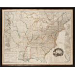
CHATELAIN, HENRI. 1684-1743. Carte De La Nouvelle France.... [Amsterdam: 1719.] Hand-colored engraved map, 420 x 490 mm. Matted and framed. Not examined out of frame. A fine map of North America, derived from De Fer's 1718 map of the inhabited parts of North America. This map was included in Chatelain's Atlas Historiques et Methodique. McCorkle 719.4; Verner & Stuart-Stubbs 11. Footnotes: Provenance The collection of Eric van Rooy. James E. Arsenault, Arrowsic, Maine, 20 November 2004. For further information on this lot please visit Bonhams.com For further information about this lot please visit the lot listing
Auktionsdetails
Versand
AGB & Wichtige Informationen
Stellen Sie dem Verkäufer eine Frage
CHATELAIN, HENRI. 1684-1743. Carte De La Nouvelle France.... [Amsterdam: 1719.] Hand-colored engraved map, 420 x 490 mm. Matted and framed. Not examined out of frame. A fine map of North America, derived from De Fer's 1718 map of the inhabited parts of North America. This map was included in Chatelain's Atlas Historiques et Methodique. McCorkle 719.4; Verner & Stuart-Stubbs 11. Footnotes: Provenance The collection of Eric van Rooy. James E. Arsenault, Arrowsic, Maine, 20 November 2004. For further information on this lot please visit Bonhams.com For further information about this lot please visit the lot listing
The Eric van Rooy Estate: A Connecticut Gentleman'
Endet ab
Ort der Versteigerung
274 Cedar Hill St
Marlborough
Massachusetts
01752
United States
...
Wichtige Informationen
This auction is now finished. If you are interested in consigning in future auctions, please contact the specialist department. If you have queries about lots purchased in this auction, please contact client services.
You are advised to visit www.bonhams.com for any additional information regarding auction 29673 which may have come to light for any Lot after producing the catalogue, which will be included in a "Sale Room Notice" accompanying each Lot.
AGB
https://www.bonhams.com/legals/
Vollständige AGBs

![ORTELIUS, ABRAHAM. 1527-1598. Americae sive novi orbis, nova descriptio. [Antwerp]: Ortelius, 15...](https://portal-images.azureedge.net/auctions-2024/bonham10926/images/00394e5a-9d41-4bca-a34e-b155000e2071.jpg?w=155&h=155)
![CHATELAIN, HENRI. 1684-1743. Carte De La Nouvelle France.... [Amsterdam: 1719.]](https://portal-images.azureedge.net/auctions-2024/bonham10926/images/184d5f4b-af1d-466b-9196-b155000e2273.jpg?w=1920&h=1920&mode=max)
![CHATELAIN, HENRI. 1684-1743. Carte De La Nouvelle France.... [Amsterdam: 1719.] - Bild 2 aus 3](https://portal-images.azureedge.net/auctions-2024/bonham10926/images/9016c2f5-2bf8-4e7b-ac33-b1680155fcc5.jpg?w=1920&h=1920&mode=max)
![CHATELAIN, HENRI. 1684-1743. Carte De La Nouvelle France.... [Amsterdam: 1719.] - Bild 3 aus 3](https://portal-images.azureedge.net/auctions-2024/bonham10926/images/a4f2a47f-7d5f-42a4-8b30-b1680155fdf2.jpg?w=1920&h=1920&mode=max)