


Eastern & Oriental Express - a vintage 20th century Orient Express silk scarf, presented in the original box and packaging. The scarf of yellow gr...
Sammlerobjekte Auktionen
Beliebte Kategorien
Antike Landkarten
Musikinstrumente & Memorabilia
Banknoten & Wertpapiere
Sport Memorabilia & Ausrüstungen
Briefmarken
Schreibgeräte
Kameras & Fotoausrüstungen
Unterhaltung Memorabilia
Religiöse & Sakrale Kunst
Wissenschaftliche Instrumente
Waffen, Rüstungen & Militaria
Wein & Spirituosen
Präparate & Naturkundliches
Küchenutensilien
Werkzeug
Eisenbahngeschichte
Ausgewählte Auktionen
Kommende Auktionen


62 Los(e)
Sortieren nach:
- Kategorie
- Liste
- Galerie
-
62 Los(e)/Seite

Los 248
An Observator Rotterdam, standing compass intended to be mounted in the wheelhouse, ca. 1950. One gl
An Observator Rotterdam, standing compass intended to be mounted in the wheelhouse, ca. 1950. One globe restored.

Los 402
Coronelli, Vincnezo Maria
Coronelli, Vincnezo Maria1650-1718, partiell kolorierte Karte wohl aus Corso Geografico Universale mit schöner Kartusche, Corso del Reno, Del Pala...

van Hammersveldt, Everard Sijmons1591-?, kolorierte Karte La principauté d'Orange et comtat de Venaissin Amstelodami 1627, Hg. Jodocus u. Henricus...

Los 404
Karte v. Kur-Baden
Karte v. Kur-BadenAnfang 19. Jhd., Karte von Kur-Baden im Jahr 1804 Herausgegeben und verlegt von Christian Friedrich Müller Hofdrucker in Karlsru...

Los 405
Sanson-Karte Cercle de Souabe
Sanson-Karte Cercle de Souabe18. Jhd., partiell kolorierte Landkarte v. Nicolas oder Guillaume Sanson, Le Cercle de Souabe subdivisé en touts les ...

Los 406
Coronelli, Vincenzo Maria
Coronelli, Vincenzo Maria1650-1718, partiell kolorierte Kupferstich-Karte, Del Palatinato, et Elettorato Del Reno Parte Orientale Descritto Dal P....

Los 407
Lotter, Tobias Conrad
Lotter, Tobias Conrad1717-1777, Kupferstich, partiell kolorierte Karte mit schöner figuraler Kartusche, Superioris atque inferioris Alsatiae Tabul...

Mariotti, Vincenzo u. de Rossi, G. G.17. Jhd., partiell kolorierte Karte von Vincenzo Mariotti, Circolo elettorale del Reno in cui principalmente ...

This map shows the world in Mercator projection, a cartographic style primarily used in the 19th century. Printed on paper and framed, this histor...

Los 409
Seutter, Georg Matthäus
Seutter, Georg Matthäus1678-1757, partiell kolorierter Kupferstich, Alsatia Landgraviatus cum utroque Marchionatu Badensi, Sundgovia Brisgovia mag...

Los 410
Zollmann-Hydrographia
Zollmann-Hydrographia18. Jhd., Stich, Gewässerkarte mit 2 vielfigurigen Kartuschen, Hydrographia Germaniae von Philipp Heinrich Zollmann, Hg. bei ...

Los 411
Sanson-Karte Rhein
Sanson-Karte Rhein18. Jhd., partiell kolorierte Landkarte v. Cordier bei Sanson, Le Cours de la Rivière du Rhin depuis sa source jusqu'à son Embou...

Los 412
Janssonius, Johannes
Janssonius, Johannes 17. Jhd., partiell kolorierte Kupferstich-Karte, Lionnois, Forest Beauviolois et Masconnois, 2 figurale Kartuschen sowie gekr...

Blaeu Karte-Archiepiscopatus Trevirensis 17. Jhd., partiell kolorierte Kupferstich-Karte, Archiepiscopatus Trevirensis, unten links bez. mit Joh. ...

Los 414
Mercator-Karte Alsatia
Mercator-Karte Alsatia17. Jhd., partiell kolorierte Kupferstich-Karte v. Gerard Mercator, Alsatia Landgraviatus cum Suntgoia & Brisgoia, unten...

Los 414
AN EARLY COLOURED MAP OF NORTHERN ENGLAND TOGETHER WITH A HENRY HONDIUS AMSTERDAM COLOURED MAP OF TH
AN EARLY COLOURED MAP OF NORTHERN ENGLAND TOGETHER WITH A HENRY HONDIUS AMSTERDAM COLOURED MAP OF THE COUNTIES OF NORTHERN ENGLAND - glazed narrow...

Los 415
Münster, Sebastian
Münster, Sebastian1488-1552, kolorierter Holzschnitt, Karte, Schwaben und Bayerlandt darbey auch begriffen der Otenwald Nortguw, womögl. aus der C...

Los 416
Münster, Sebastian
Münster, Sebastian16. Jhd., Buchseite wohl aus der Cosmographie mit kolorierter Karte, ccclxxxj Das dritt Buch der Weltbeschreibung durch Sebastia...

Los 417
Münster, Sebastian
Münster, Sebastian16. Jhd,, Buchseite wohl aus der Cosmographia mit Karte, Das Dritte Buch Von dem Elsaß und seiner grossen Fruchtbarkeit dem kein...

Los 418
Ruscelli, Girolamo
Ruscelli, Girolamo?-1566, Tabula Europae IIII, trapezförmige Karte mit einigen Tieren, wohl aus La Geografia di Claudio Tolomeo Alessandrino, Gebr...

Los 419
Landkarte Deutschland
Landkarte Deutschlandrandkolorierte Karte, Deutschland, in Randkartusche bez. Allemagne Par N. Sanson le fils Geographe du Roy, Gebr.sp., H. 20, B...

Los 420
Reilly, Franz Johann Joseph
Reilly, Franz Johann Joseph 1766-1820, partiell kolorierter Kupferstich, Karte, in Kartusche bez. mit Das Fürstenthum Querfurt Nro. 366, Gebr.sp....

Los 421
Ruscelli, Girolamo
Ruscelli, Girolamo?-1566, Kupferstich-Landkarte, Tavola Nuova di Germania, wohl aus La Geografia, Gebr.sp., H. 21, B. 28, Passepartout, Ra.

Los 422
Bodenehr, Gabriel
Bodenehr, Gabriel1673-1765, grenzkolorierte Kupferstich-Karte, Die West See auch das Teutsche Meer, von den Hollaendern aber die Noordsee geheisse...

Los 423
Karte Wirtenberg Ducatus
Karte Wirtenberg Ducatusdatiert 1579, kolorierter Kupferstich, Abraham Ortelius, Georg Gadner, Wirtenberg ducatus accurata descriptio , in qua omn...

Los 424
Seutters Circulus Suevicus
Seutters Circulus Suevicus 18. Jhd., Matthäus Seutter, kolorierter Kupferstich, Landkarte, Circulus Suevicus in quo Ducatus Wirtenbergensis cum re...

Los 425
Weltkarten-Schrank
Weltkarten-Schrank1960er Jahre, großer Weltkarten-Hängeschrank mit 20 gerollten Landkarten aus dem Nachlass des Bundeskanzlers a.D. Dr. Kurt Georg...

Los 426
de Wit, Frederick
de Wit, Frederick17. Jhd., kolorierte Kupferstich-Karte, Belgium Foederatum emendate auctum et novissimé editum, allegorische Kartusche, unten lin...

Los 427
Hogenbergh, Franz
Hogenbergh, Franz1540-1592, kolorierte Landkarte, Kupferstich, Wirtenbergensis Ducatus vera Despcription Tubingae edita 1558, mittig links am Rand...

Los 428
große Weltkarte
große Weltkarte18. Jhd., große randkolorierte Weltkarte, Western part of the mediterranean sea with the coasts of Spain France Italy Barbary Easte...

Charte über das Grossherzogthum Baden1. Hälfte 19. Jhd., partiell randkolorierte Karte in Segmenten auf Gewebe, F. X. Hutter, Charte über das Gro...

Los 577
A COLLECTION OF THIRTY-THREE 19TH CENTURY LEATHER BOUND BOOKS AND MAPS RELATING TO YORKSHIRE
A COLLECTION OF THIRTY-THREE 19TH CENTURY LEATHER BOUND BOOKS AND MAPS RELATING TO YORKSHIRE
Los 579
A COLLECTION OF SIX FOLIO BOOKS
A COLLECTION OF SIX FOLIO BOOKS comprising of 'Old English Coaching Inns' by J C Maggs, 'The Costume of Yorkshire' By George Walker, 'Survey of th...

36 CM HIGH AND 15 CM DIAMETER

Robert Morden - A late 17th century hand coloured & engraved map of Gloucester Shire (Gloucestershire). With cartouche to upper left hand side rea...

AN EARLY JOHN SPEED COLOURED MAP OF THE NORTH & EAST RIDINGS OF YORKSHIRE 1676 edition by Bassett and Chiswell TOGETHER WITH AN ORIGINAL EARLY ROB...

JOHN BLAEU AN EARLY MAP OF “LORN” ON THE WEST COAST OF SCOTLAND - 1654 edition, mounted in glazed frame44.5cm high 53cm wide

A COLLECTION OF THREE 17TH CENTURY MAPS two by Johannus Blaeu of West Riding 1648 and North Riding 1645, and a John Speed of West Riding 1676. (3)...

Los 847
Ansicht von Bielefeld
Ansicht von Bielefeld19.Jh.Ansicht von Bielefeld. Seiner Majestät Friedrich Wilhelm IV. Könige von Preussen.- Kupferstich v. Joh. Poppel nach Th. ...

Los 849
Römischer Kalender
Römischer Kalender18.Jh.Kalendarium Juliano - Romanum Perpetuum.- Teilkolor. Kupferstich nach Matthäus Seutter. Mittelfalz. Leicht nachgedunkelt/g...

Los 850
Karte von Essex
Karte von Essex19.Jh.Teilkolor. Kupferstich, v. John Cary, aus: New & Correct English Atlas. Leicht nachgedunkelt/fleckig/verschmutzt. 21 x 26...

Los 851
Karte der Ostsee
Karte der Ostsee18.Jh.Tabula Hydrographica Maris Baltici.- Teilkolor. Kupferstich, ersch. bei Johannes Janssonius. Mittelfalz. Nachgedunkelt/gebrä...

Los 1006
A Lot of 2 Celestial Maps
2 pieces Celestial maps Doppelmayr consisting of Hemisphaerio Boreali and Misphario Australi 59 x 49 cm.

1953-1990 A.D.. Susan Youngs (ed.) - The Work of Angels - London, 1989, card covers; Ordnance Survey Map of Southern Britain in the Iron Age - car...


Los 1331
A Collection of Maps
Including Veere including 18th century largest 48 x 42 cm.


Los 1430
Railway interest Isle of Man Railway Company and Road Services poster for Peel Harbour, Edward
Railway interest Isle of Man Railway Company and Road Services poster for Peel Harbour, Edward Johnsons & Co Limited Manchester Color Printers, mo...

Lower Palaeolithic Period, circa 500,000-240,000 B.P.. Substantial cleaver with one worked edge; old collector's label 'From the River = Sandown, ...

Los 1535
Stone Age 'Buigny' Flint Axehead
Neolithic Period, circa 3000-2000 B.C.. Rectangular in plan and biconvex in section with old inked legend 'BUIGNY'. Cf. MacGregor, A. (ed.), Antiq...

Lower Palaeolithic Period, circa 1,000,000-500,000 B.P.. Biconvex in section with large rounded butt and narrow tip (absent). Cf. MacGregor, A. (e...

The Vine and it's Fruit, The Production of Wine 1875 including fold out coloured map

Los 1632
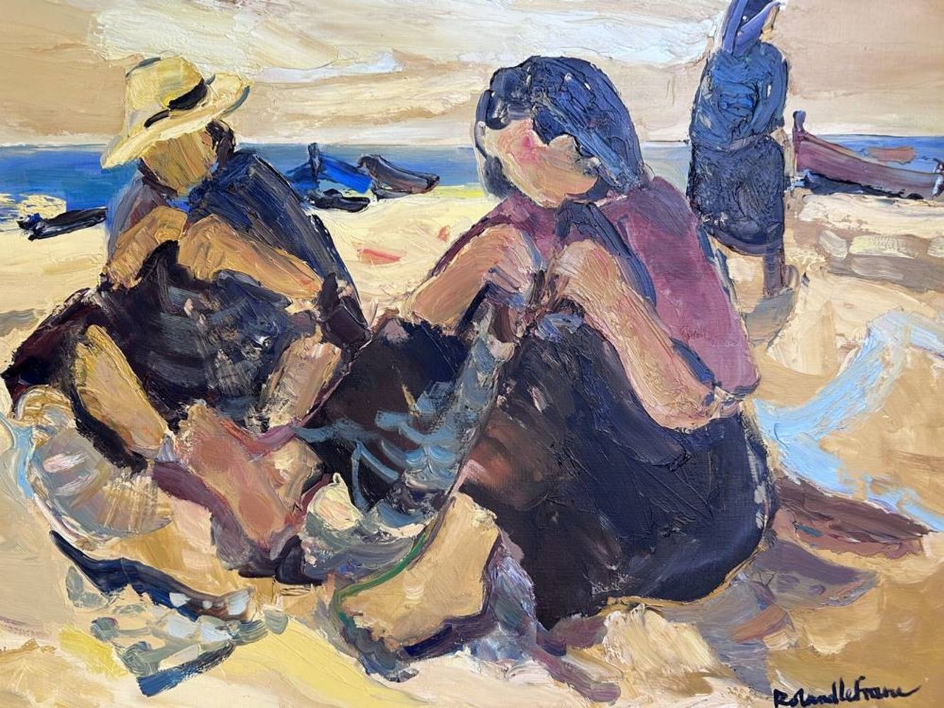
View of the town at dawn, signed lower right corner, attributable to Eliseo Meifren Roig (Barcelona,
Table measurements: 30 x 19 cm, frame measurements: 50 x 40 cm

Vintage Crams Imperial twelve inch world globe with atlas design stand

Antique German map of the Prussian States in two parts, Herrn Von Nagler 1825 housed in a cardboard sleeve, each part 89cm x 48cm

Los 2500
Coloured folding map of England & Wales published by W Faden 1818, housed in a cardboard case, 127cm
Coloured folding map of England & Wales published by W Faden 1818, housed in a cardboard case, 127cm x 97cm

Los 2501
18th century hand coloured map of Suffolk sold by W Faden Charing Cross, dated January 1st 1787,
250118th century hand coloured map of Suffolk sold by W Faden Charing Cross, dated January 1st 1787,
18th century hand coloured map of Suffolk sold by W Faden Charing Cross, dated January 1st 1787, housed in a cardboard case, 80cm x 60cm

Los 2502
Hand coloured folding map of Asia Minor by Joseph Parker Oxford 1832, housed in a cardboard
Hand coloured folding map of Asia Minor by Joseph Parker Oxford 1832, housed in a cardboard sleeve, 100cm x 65cm

Los 2503
Antique hand coloured French folding map of Germany, Belgium and Holland dated 1808, 14cm x 55cm
2503Antique hand coloured French folding map of Germany, Belgium and Holland dated 1808, 14cm x 55cm
Antique hand coloured French folding map of Germany, Belgium and Holland dated 1808, 14cm x 55cm